Palm City, Florida
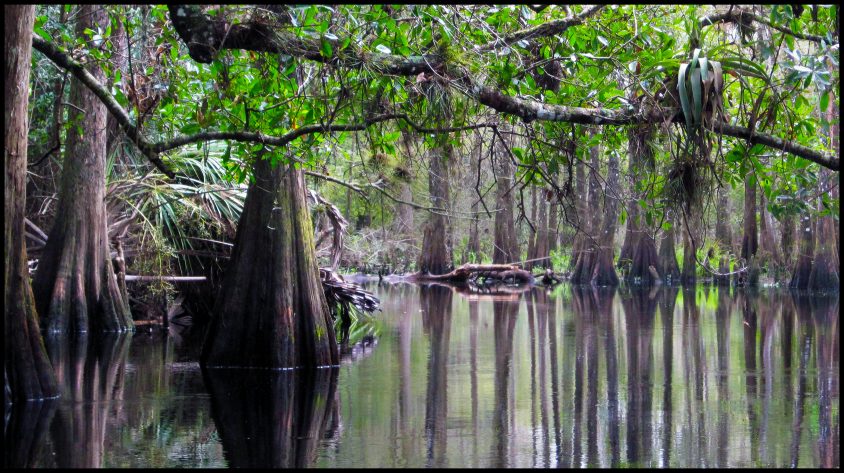
“Fisheating Creek is unique in Florida,” said George C. “Chappy” Young, Jr., president of GCY, Inc., a Palm City, Florida – based surveying and mapping firm. “It is as close to being in the same pristine condition as it was 150 years ago when Florida gained statehood.” In November of 1999, Young’s firm took up the challenge of surveying 60,000 acres along and near the banks of this scenic waterway for the Bureau of Survey and Mapping division of the Florida Department of Environmental Protection. West of Lake Okeechobee, Fisheating Creek’s headwaters begin in Highlands County but most of the approximately 45-mile creek rambles through Glades County before emptying into the lake.
The project covers a territory approximately the combined size of Jensen Beach, Rio, Stuart, Golden Gate and Hobe Sound. It covers approximately 94 square miles and has a perimeter boundary of more than 156 miles. This is the largest single acquisition of preservation lands the state has undertaken to date, said Young. The area has long drawn outdoor enthusiasts who know of its scenic, wildlife and recreational attributes. The creek is an icon to generations of South Floridians, who as young scouts had opportunities to camp along this creek, said Young.
The waterway forms an extensive watershed area that covers hundreds of square miles and supports species such as Florida black bear, alligator, deer, bass, and a wide array of birds. The survey project represents one of the final stages in a lengthy ordeal to save this waterway for the benefit of the public.
In 1989 the creek fell into controversy when Lykes Bros. Corp., owners of the land along the creek, claimed ownership of the creek and creek bed, and closed it to all public uses. The State of Florida, joined by environmental groups, including Sierra Club and Florida Wildlife Federation, sued the Tampa-based citrus, cattle, and insurance company in an effort to reopen the creek. Thus began a roughly 10-year court battle.
The legal issue hinged on a seemingly simple question: Was this waterway navigable in 1845 when Florida became a state? If yes, then as submerged lands, the creek bed belongs to the state. Lykes Bros., however, contended that it was not a navigable body of water, and therefore, since the company owned the land along the creek, it owned the creek as well. The state circuit court agreed with the state on the issue. In 1999, before Lykes appealed the verdict, the state and the company reached an out-of-court settlement. In October last year, Gov. Bush and the Cabinet voted to buy some of the land as well as future development rights and conservation easements from Lykes for more than $46 million.
The state hired GCY, founded by Young in 1984, to complete a boundary survey. The company recently finished the first phase and has begun the second of what may be a five-phase project involving more than 151,000 acres. But Lykes Bros. and the state have yet to negotiate future phases. One type of boundary survey, a RETRACEMENT SURVEY, requires a surveyor to be part detective and part archeologist.
We research old records and maps, then headed into the field to try to locate evidence of the original section corners set in the 1800s by the original federal surveyors,” said Young. “But after 150 years, few of those original wooden posts are still around, maybe as little as one or two percent. They have rotted, burned or been covered over. And nearby trees, called witness trees, used as landmarks are also usually gone.” Young has had as many as five crews working on site at one time. Each crew consists of three people – a crew chief, who is the most experienced and skilled at interpreting the information, of knowing the difference between an old tree stump and a section corner; an instrument man, who makes actual measurements; and a rod man, who is an entry-level trainee.
GCY has utilized state of the art global positioning systems (GPS) for increased accuracy and precision. GPS technology was first developed by the U.S. Department of Defense and utilizes earth-orbiting satellites to calculate a 3-D position for virtually any location in the world. GPS saves money and man-hours. “Without GPS technology, a survey of this size would have taken at least three years. We are doing it in seven months,” said Young. “One pond covered more than 700 acres but contained five sections or quarter sections. It took us two and a half days to survey. Without GPS, we would have been in that one spot for three weeks or longer. The logistical problems alone would have been tremendous.” Varied terrain distinguishes this project. “A large portion of the site is prairie and cypress heads,” said Chip Allen, GCY vice president.
During his time on the project, Young has been impressed by the variety of species he has encountered from otters and panthers to eagles and swallow-tailed kites. GCY surveyed other environmentally sensitive lands such as Archie Carr Beach, a section of coastline between Melbourne and Wabasso, which is an important nesting area for loggerhead sea turtles. Other sites have included Kissimmee Prairie in central Florida, Savannahs in Port St. Lucie and Jensen Beach, Maritime Hammocks in Brevard, and along the Atlantic Ridge from Jonathan Dickinson to Cove Road.
With about 30 employees, GCY serves both public and private sector clients throughout the southeastern United States and the Bahamas. It handles an average of 20 to 30 jobs at any one time. Clients have included Indian River Plantation, Willoughby Country Club, Mariner Sands, and Miami Dolphins owner Wayne Huizenga. The company maintains memberships in both Florida Society of Surveying and Mapping and American Congress on Surveying and Mapping. “The challenge today is keeping our technology updated,” said Young.
For more information, contact GCY, Inc., 772-286-8083